Mount St. Helens erupts on May 18, 1980
May 16, 2023 at 3:27 p.m.
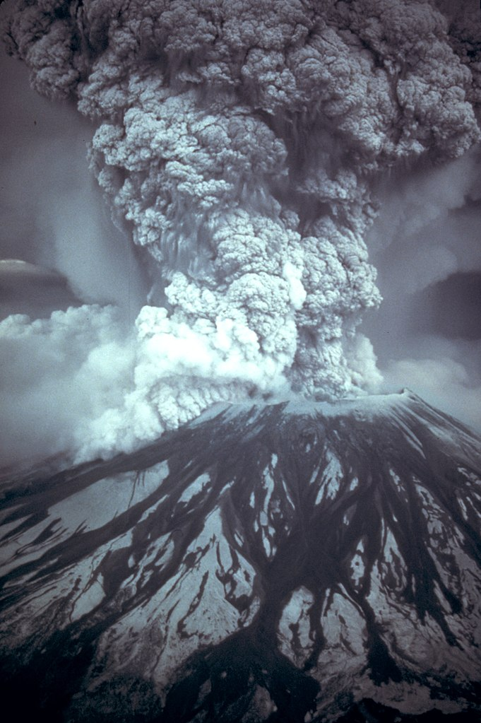
On May 18, 1980 at 8:32 a.m., the earth rumbles underneath Mount St. Helens, a peak in Skamania County in southwestern Washington. Moments later an explosion blasts away a side of the mountain in a major volcanic eruption. The volcano causes the deaths of 57 people. The destruction is widespread but especially severe in Skamania and Cowlitz counties as boiling gas and mud scour 200 square miles of forest and 30 miles of State Route 504. Some 1,000 miles of state highways and roads have to be closed, some for months, and highway repairs alone run into hundreds of millions of dollars.
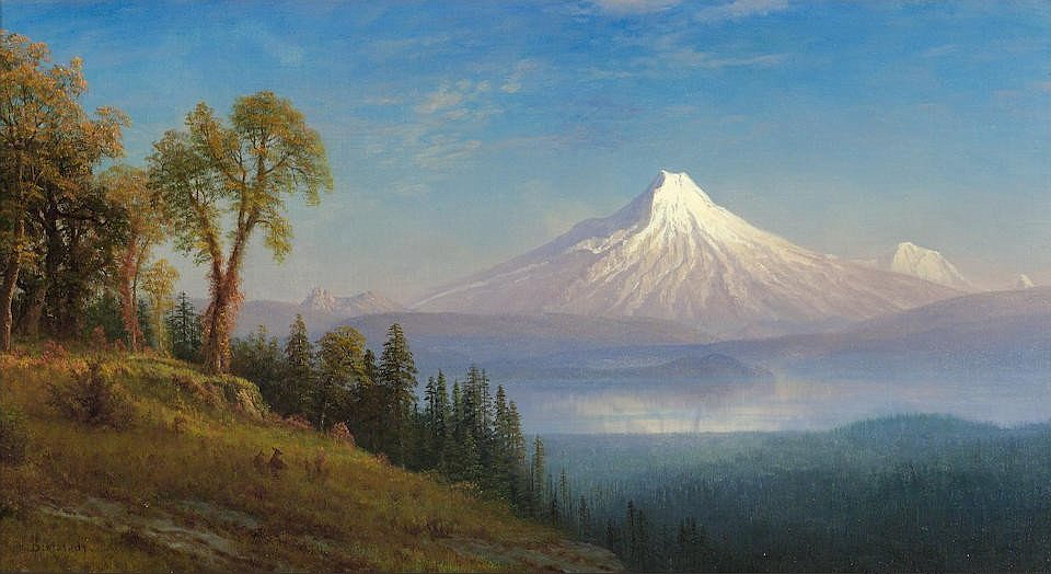
 The beauty of pre-eruption Mount St. Helens reflected in Spirit Lake
Steam and Ash
The first visual signs of Mount St. Helens’ volcanic activity in 123 years occurred on March 27, 1980, when a steam explosion and crater opening occurred at the mountain’s peak. For the next few weeks steam and ash periodically vented out of the growing crater. A bulge on the mountain’s north side, noticed at the end of April 1980, grew larger and larger so that by mid-May the north side of Mount St. Helens bulged out 300 feet and increasing at a rate of five or six feet a day. This was caused by magma rising inside the mountain.
 Pre-avalanche eruption, Mount St. Helens, April 10, 1980. Courtesy United State Geological Survey
On a recent visit Day Karr had taken a photo of Mount St. Helens which he sold to a national wire service, and he was returning to the mountain hoping to get some more good shots. On the morning of May 18 the Karrs had gotten up early and were in their pickup truck when the mountain erupted.

Harry R. Truman was the owner and caretaker of Mount St. Helens Lodge at Spirit Lake. He came to fame when he refused to leave his home during the mandatory evacuation. He perished in the volcanic debris.
The Volcano Erupts
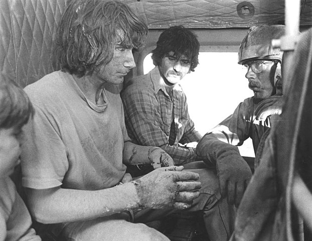 Evacuees being rescued from Mount St. Helens by the National Guard
- Sound and shock waves shot straight up towards the heavens.
- At 660 degrees F., hot gases and pulverized pieces of the mountain were blasted to the north and swept along the ground at speeds of at least 300 mph. Within about a minute of the eruption, the Karr pickup truck was overwhelmed and its three occupants were killed. The lateral blast was so powerful that all trees and vegetation in a six mile radius to the north of Mount St. Helens, including where the Karrs were, vaporized.
- In less than five minutes after the eruption, the seething blast continued out 18 to 23 miles from the mountain, killing nearly all vegetation. Trees, mainly Douglas Firs, some 200 feet high, were stripped of branches and bark and blown down like toothpicks. Some old growth trees were picked up, roots and all, and thrown over a ridge 1,500 feet high.
- The top of the mountain, composed of rock debris, snow, and ice, rushed down the mountain at speeds up to 200 mph and over a portion of the lateral blast area. Most of the debris landslide flowed to the northwest following the North Fork of the Toutle River. In 10 minutes it had traveled 13 ½ miles. The mountain avalanche covered a 24 square mile area to an average thickness of 150 feet -- in some places it was 600 feet thick. In moments Mount St. Helens dropped from being the fifth highest mountain in Washington at 9,677 feet to being the 30th highest peak at 8,364 feet. The south side of the mountain lost 1,313 feet in elevation and the north side lost about 2,900 feet. The volcano left a crater more than a square mile wide, about the size of Seattle's downtown business area.
- An ash plume roared out of the top of the mountain and within 15 minutes reached a height of 15 miles above the mountain. Prevailing winds blew dense clouds of black ash to the east that blocked the sun and turned day into total darkness over the land it crossed. Then a rain of powdery ash began to fall out of the "clouds" onto the countryside. In just over an hour the ash cloud reached Yakima 60 miles away and put the city in total darkness. The ash eruption continued roaring out of the mountain for 9 hours. Ash fell along the cloud’s route as far east as the Great Plains about 900 miles from the mountain. Within 10 miles of the mountain, 10 inches of ash accumulated on the ground. Within 60 miles the ash fall was one inch, within 300 miles, one-half inch. The ash cloud took three days to reach the East Coast and 15 days to circumnavigate the world.
Like Watching the End of the World
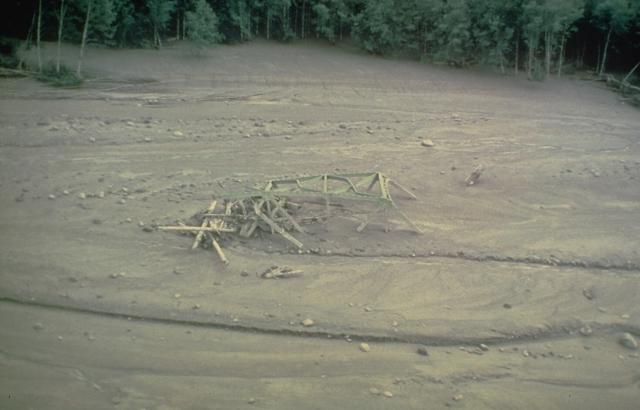
The twisted girders of a highway bridge lie entombed in mudflow deposits from Mount St. Helens. This May 18, 1980 mudflow was produced by dewatering of the debris-avalanche deposit in the North Fork of the Toutle River and traveled as far as the Columbia River, decreasing the depth of the navigational channel from 11 meters to 4 meters. Photo courtesy Dan Miller, U.S. Geological Survey
"I had just started to drive onto the overpass [over Valley Freeway] and there it was. It was almost like a motion picture, or, more accurately, a painting. There was such a surreal feel to it all, it was like watching the end of the world come slowly, and you could do nothing but watch. Once drivers noticed all the people watching from the road shoulders, they pulled over and hardly anyone was moving on the streets in Auburn. Everyone just stared with their mouths open in shock. I was late for work because I just couldn't pull myself away from the sight. You could feel the tension/excitement that rolled off everyone. It was so thick in the air that I could almost reach out with my hand and grab ahold of it" (Seattle Post-Intelligencer May 8, 2000).
It took about an hour for the sound and shock wave of the explosion to bounce off the upper atmosphere and reach as far as King County. Some residents heard a series of very loud "whumps" described as the sound of “heavy artillery fired [from] a short distance away” (Carson, 39). The shock waves rattled windows and caused dishes to fall from shelves. The sound of the Mount St. Helens eruption was heard as far away as Saskatchewan.
The disaster killed 57 people. One couple died while watching the eruption 25 miles away from the mountain. The deaths were caused by heat, by being buried under the debris avalanche, or by suffocation when ash raining down was inhaled. Amazingly, over the next two days from 125 to 150 survivors were rescued from the blast area.
Tragically, Day Karr’s hope of a photograph that could be sold nationally was realized when a photographer from the San Jose Mercury took a photograph of the Karr pickup truck showing the body of one of the children in the back of the truck.
A stunning 200-foot thick lahar (flow of mud, trees, ice, and debris) rushed down the Toutle River Valley at 10 to 25 mph and into the Cowlitz River. Eighteen hours after the flow started, it emptied into the Columbia River 75 miles from the mountain. The depth of the Columbia was reduced from 40 feet to 14 feet and shipping was blocked on the river for one week.
An Eerie Landscape
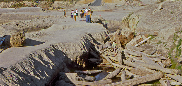 One of many road bridges on the Toutle River destroyed by mud flows caused by the May 18, 1980 eruption of Mount St. Helens, just over 4 months earlier.
On May 20, Washington Governor Dixy Lee Ray flew over Mount St. Helens and on her return stated, "I feel like I’ve just come back from the moon." She described it as an "eerie, undulating landscape" (Post-Intelligencer May 21, 1980).
To give some sense of the enormity of the eruption and the destruction that it created, the Everett Herald imagined the crater of Mount St. Helens where the professional sports stadia are, just south of downtown Seattle. The newspaper assumed the terrain was the same as it was around the mountain before it erupted on May 18, 1980. Following is the Herald’s description of the area affected by the volcano:
“It would have, in moments, devastated with heat, ash, concussion and mud all of downtown Seattle, North Seattle [Shoreline] and beyond as far as Edmonds, some 20 miles to the north. The devastation would have crossed Puget Sound, smashed the northern third of Bainbridge Island and sent two huge mud flows crashing as far as Hood Canal.
Renton would have been inundated with mud. Kirkland and Bellevue would have been destroyed. The western shore of Lake Sammamish would have been devastated and the lake itself would be buried under a thick ash cover that would extend across the Cascade foothills to cover Skykomish and Index before continuing into Eastern Washington and beyond” (Everett Herald).
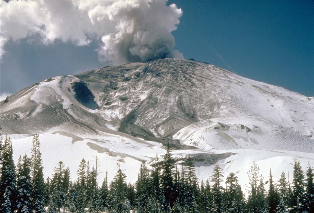
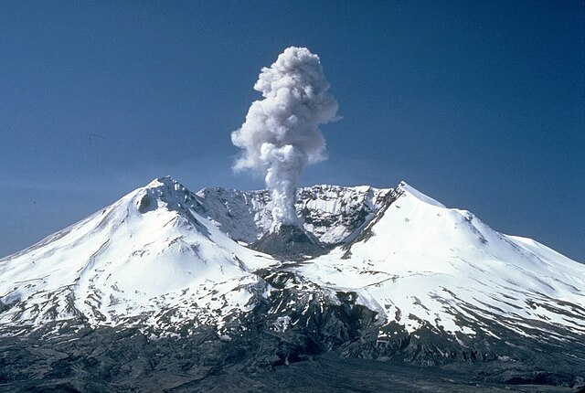 A plume rises from Mount St. Helens’ crater two years after the eruption
The following people were killed in the Mount St. Helens eruption:
- BLACKBURN, Reid Turner, 27, Vancouver, WA, Photographer
- BOWERS, Wallace Norwood, 41, Winlock, WA (Never Recovered)
- CRALL, Terry A., 21, Kelso, WA
- COLTEN, Joel K., 29, Wyncote, PA
- CONNER, Ronald Lee, 43, Tacoma, WA
- CROFT, Clyde Andrew, 36, Roy, WA
- DIAS, Jose Arturo, Woodburn, WA, Logger
- DILL, Ellen Loy, 53, Kirkland, WA (Never Recovered)
- DILL, Robert, 61, Kirkland, WA (Never Recovered)
- EDWARDS, Arlene H., 37, Portland, OR
- EDWARDS, Jolene H., 19, Portland, OR
- FADDIS, Bruce Edwards, 23, Bend, OR (Never Recovered)
- FITZGERALD, James F., Jr., Moscow, ID
- GADWA, Thomas G., 35, Montesano, WA, Logger (Never Recovered)
- HANDY, Allen R., 34, Tacoma, WA
- HIATT, Paul (Never Recovered)
- JOHNSTON, David A., Menlo Park, CA, USGS Employee (Never Recovered)
- KARR, Day Andrew, 37, Renton, WA
- KARR, Day Bradley, Renton, WA
- KARR, Michael Murray, Renton, WA
- KASEWETER, Robert M., 39, Portland, OR (Never Recovered)
- KILLIAN, Christy Liann, Vader, WA
- KILLIAN, John G., 29, Vader, WA (Never Recovered)
- KIRKPATRICK, Harold (Butch), 33, Newberg, OR
- KIRKPATRICK, Joyce M., 33, Newberg, OR
- LANDSBURG, Robert Emerson, Portland, OR, 48, Photographer
- LYNDS, Robert, 25, Kelso, WA (Never Recovered)
- MARTIN, Gerald O., 64, Concrete, WA
- MOORE, Gerald Lloyd, Kelso, WA
- MOORE, Keith A., 37, Kelso, WA (Never Recovered)
- MOORE, Shirley, 49, Kelso, WA
- MORRIS, Kevin Christopher, 7, Olympia, WA
- MORRIS, Michele Lea, 9, Olympia, WA
- MURPHY, Edward Joseph, 62, Renton, WA (Never Recovered)
- MURPHY, Eleanor Jeanne, Renton, WA (Never Recovered)
- PARKER, Donald R., 45, Portland, OR (See PARKER, Richard A.)
- PARKER, Jean Isabell, 56, Portland, OR (SEE PARKER, William Paul)
- PARKER, Natalie Ali, Westport, WA
- PARKER, Richard A., 28, Shelton, WA (See PARKER, Donald R.)
- PARKER, William Paul, 46, Portland, OR (See PARKER, Jean Isabell)
- PLUARD, Merlin James, 60, Toledo, WA (Never Recovered)
- PLUARD, Ruth Kathleen, Toledo, WA (Never Recovered)
- ROLLINS, Fred D., 58, Hawthorne, CA
- ROLLINS, Margery Ellen, Hawthorne, CA
- SCHMIDT, Paul F., 29, Silverton, OR
- SEIBOLD, Barbara Lea, Olympia, WA
- SEIBOLD, Ronald Dale, 41, Olympia, WA
- SELBY, Donald James, 48, Lake Stevens, WA
- SHARIPOFF, Evlanty V., Mt. Angel, OR, Logger
- SKOROHODOFF, Leonty V., 30, Woodburn WA, Logger
- THAYER, Dale Douglas, 26, Kelso, WA (Never Recovered)
- TRUMAN, Harry R., 83, Spirit Lake, WA (Never Recovered)
- TUTE, James S., Canada (Never Recovered)
- TUTE, Velvetia, Canada (Never Recovered)
- VARNER, Karen Marie, 21, Kelso, WA
- WETHERALD, Beverly C., Portland, OR (Never Recovered)
- ZIMMERMAN, Klaus, Spokane, WA
Sources:
The Daily News (Longview) and The Journal-American (Bellevue), Volcano: The Eruption of Mount St Helens (Longview, WA: Longview Publishing Company, 1980), 26, 31, 36; Scott Shane, Discovering Mount St. Helens: A Guide to the National Volcanic Monument (Seattle: University of Washington Press, 1985), 3, 4-5, 7-8, 8-11; Rob Carson, Mount St. Helens: The Eruption and Recovery of a Volcano (Seattle: Sasquatch Books, 1990), 39-40, 56; People December 14, 1981, p. 50-52; The Seattle Times, May 21, 1980, p. D2; Seattle Post-Intelligencer, May 21, 1980, p. A1, A2, A3; May 25, 1980, p. F7; May 26, 1980, p. A12; June 15, 1980, p. A11; Daily Record Chronicle (Renton), May 28, 1980, p. A2, A8; Everett Herald, June 14, 1980, p. 3B; Seattle Post-Intelligencer, May 8, 2000, p. 7; "Eruption Summary - May 18, 1980 Eruption of Mount St. Helens" compiled by Lynn Topinka, 1997, in (http://vulcan.wr.usgs.gov/Volcanoes/ MSH/May18/summary_may18_eruption.html); Names of victims courtesy I Dream of Geneology website accessed August 31, 2006 (http://www.idreamof.com/disaster.html).
Note: This essay was updated on March 5, 2005. Names of the victims were added on August 31, 2006, and the identity of the counties most affected was corrected on September 5, 2014.
You can read the Historylink article here: Mount St. Helens erupts on May 18, 1980. - HistoryLink.org
Latest Stories

Cantaloupe and Melons Pack a Healthy Punch
Eating cantaloupe and other melons on a regular basis may help improve your vision and provide a host of other health benefits
READ MORE...
Where To See Wildflowers — And Avoid the Crowds
So, if you want to sing “The Hills Are Alive…” to the birds, rodents and you don't want to fight for parking or have hordes of people in your photos, here are the trips for you
READ MORE...
Volunteers Essential to Protecting Elders in Long Term Care
The Washington State Long-Term Care Ombudsman Program advocates for the rights of residents living in long term care
READ MORE...
55+ Travel Club
Be on the lookout for news about an exciting new Northwest Prime Time venture, the Northwest Senior Travel Club
READ MORE...