Walking Washington's Riverfronts
May 27, 2018 at 7:29 a.m.
Rumors about “the mighty river of the West” drew early explorers from around the world, looking for a waterway across the North American continent.
From the Pacific Ocean, they found and named the Columbia River, but it did not go where they hoped it would. After 200 miles it turns north rather than leading east.
Although the explorers were disappointed, the rivers of Washington have boosted the growth and vitality of our state’s cities for centuries. Vancouver, Yakima, the Tri-Cities, Wenatchee, Spokane and Everett all flourished on the banks of powerful rivers. Several cities have reclaimed these heavily used riverfronts for recreation. You can walk or bike for miles through urban history. The trails are mostly paved and relatively flat.
Vancouver
Begin in Vancouver, on the lower Columbia. The American Robert Gray named the river, but it was an English explorer who put Vancouver Point on a map. A British fur-trading company chose this point for its headquarters. When canoe-loads of furs were paddled down the river, more than a thousand people gathered at Fort Vancouver, making it the first real city in the Pacific Northwest in the 1820s. A century and more later, thousands of workers streamed to shipyards in Vancouver during two world wars.
To celebrate its relationship to the river and transform an industrial waterfront into more friendly space, Vancouver has strung together more than five miles of the Columbia River Renaissance Trail. It begins at Waterfront Park, 115 Columbia Way. Sidewalks and paved trails lead through parks, along beaches and past new housing developments on the wide, placid but busy river. Right at the beginning, across Columbia Way on a crosswalk, is a spur trail under the railroad line to the Land Bridge. At significant places along the lower Columbia River, artist Maya Lin has redesigned landmarks at the confluence of Native American, European and American cultures. The land bridge reconnects the river to the fort plain, now the Fort Vancouver National Historic Preserve, worth a day’s rambling on its own.
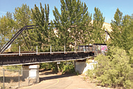
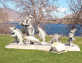
One mile farther along is a bronze statue of Ilchee, a member of the powerful Chinook tribe who controlled the lower Columbia in the early 1800s. A short distance beyond is Wendy Rose, a stainless-steel welder sporting a jaunty red bandanna. At three-and-a-half miles is a side-trail to the Kaiser Viewing Tower, overlooking the former shipyards where more than 140 Victory ships were built during World War II, many welded by women. The trail continues another 1.5 miles to Wintler Park.
Tri-Cities
From Vancouver, follow the Columbia River 200 miles upstream as it flows over rapids now buried by dams. Past the Cascade Mountains, the hills above the river are dry and brown. Where the Columbia turns north at the Tri-Cities is where hope ended for a waterway across the continent.
But two other rivers, the Snake and the Yakima, flow into the Columbia here from the east and the west. Native Americans lived and fished at the confluence for more than 11,000 years. Tribes gathered in great numbers when the salmon swam up the Columbia. Lewis and Clark and their Corps of Discovery canoed down the Snake and arrived at the Columbia on October 16, 1805, knowing they had found the last leg of their journey across the continent. The Indians invited the Corps to join them in a smoke and an exchange of food and gifts.
Three cities developed on the banks of the three rivers. Pasco and Kennewick grew along railroad routes and from farming irrigated by the Columbia Irrigation Canal. Richland was a sleepy ranching and farming town, the commercial center of rich land watered by the rivers. Then the federal government chose Hanford as a site to produce plutonium during World War II. Transformed almost overnight, Richland became a nuclear city.
The Sacagawea Heritage Trail, named after the one woman in the Corps of Discovery, connects the three cities with a 23- mile paved loop. The trail follows both sides of the Columbia from its confluence with the Snake on the south to its confluence with the Yakima on the north end. You may walk or bike the trail in segments, one city at a time. Sacajawea State Park, on the Pasco side at the confluence of the Snake and the Columbia, is a good starting point on the southern end of the trail. The Hanford Reach Interpretive Center is a good access spot on the Kennewick/Richland side at 1943 Columbia Park Trail.
Other trails and spurs intersect and extend the trail, including the Richland Riverfront Trail, which focuses on nuclear history. It may be picked up at Howard Amon Park, 500 Amon Park Drive.
Yakima
The Yakima River flows into the Columbia after a long journey from the Cascade Mountains through the Yakima Valley. The federal Reclamation Act of 1902 authorized thousands of miles of irrigation canals, turning the valley into the “fruit bowl of the nation.”
The city of Yakima, at the confluence of the Yakima and Naches rivers, is the fruit bowl’s market hub. From Fruit Row on the railroad lines downtown, fruit and vegetables were stored, dried, canned or packed, and shipped to the nation and the world.
The Yakima Greenway parallels the two rivers for more than twenty miles with ten access points. The trailhead on the west end is at Myron Lake. The Century Landing is on the south end.
Midway through the trail is the Naches River railroad bridge. Hobos gathered beneath it in the days when it was possible to hop a passing freight train to the next job. Twelve-year-old William O. Douglas, the Supreme Court justice-to-be, camped and talked with the hobos when he headed out of Yakima on his periodic rambles into the mountains.
Rotary Lake, near the junction of rivers, is the former millpond for the Cascade Lumber Company. A thousand logs from upriver logging would float down the Yakima River and arrive each day during the spring log drives. Since the mill closed in 2006, private efforts have reclaimed the riverfront for walking, biking and fishing.
Wenatchee
On his ambitious exploration of the length of the Columbia River for the Northwest Fur Company, David Thompson canoed past the mouth of the Wenatchee River on July 7, 1811. Eighty years later a city grew where the two rivers converge.
Wenatchee had both water transportation and a railway line, the Great Northern, going through town, but the river was hard to navigate. Thompson had to portage his canoes around rapids. The land on narrow benches above the river was dry with poor soil. Not until large-scale irrigation diverted water from the Wenatchee River starting in 1904 did the land produce fruit and launch Wenatchee as the self-proclaimed Apple Capital of the World.
Rufus Woods moved to town a year later and started a newspaper. Woods was a relentless promoter of dams on the Columbia. As Franklin Delano Roosevelt made campaign promises in 1932, he included building the Grand Coulee Dam but it took all the political and publicity power Woods and others could muster to counter arguments they were “coulee communists” for advocating publicly-owned power. The Grand Coulee opened some 99 miles upstream in 1942, in time to power aluminum production for WWII. The Rock Island and Rocky Reach dams turned the mid- Columbia into a powerhouse.
The Apple Capital Loop borders the now placid river. The multi-use trail stretches five miles on the west and another five miles on the east. On the east side, there is access and parking at the 19th Street trailhead. On the west side, access the loop at Confluence Park, Walla Walla Point Park and the Riverfront Park. The loop crosses the river on the north end over the Odabashian Bridge and on a footbridge on the southern end. Best walking parts are between the parks on the west side or along the less urban east side.
Spokane
North of Wenatchee, the Columbia curves east again through the Grand Coulee Dam, pooling in Lake Roosevelt. The Spokane River flows in from the east, a 111-mile journey from Lake Coeur d’Alene, Idaho. Historically the river was a salmon river, but a city grew on its banks because of the power that could be harnessed by three falls that run through the heart of Spokane. Mills ground grain into flour and shipped it as far away as London, England. In 1910, the Washington Water Power Company built a substation on the river, generating electric power for the next 120 years, longer than any other hydroelectric site operating in Washington.
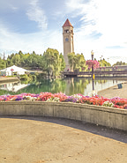
Spokane abused the river in its midst until the city undertook a world’s fair, Expo 74, with an environmental theme. Riverfront Park in the heart of downtown would be the centerpiece. Power grabs were reduced to increase the river’s flow; railroad tracks were pried from its islands and water pollution was abated.
The Centennial Trail runs through the park, part of a 36-mile trail along the river from Spokane House, an 1800s fur trading post, to Horse Slaughter Camp, site of a military conflict near the Idaho border. Access the trail in Spokane at Riverfront Park and walk or bike to your heart’s content in either direction.
Leaving the Columbia River and the east side of the state, head west to Puget Sound where multiple rivers flow down from the Cascade Mountains.
Everett
Everett’s wealth began at a bend of the Snohomish River. In 1863, Eugene D. Smith set up the first logging operation in a community he named Lowell. Because the water was deep and the undercurrent strong at this bend, the river held logs against the bank until they could be driven downriver to a mill on Gardner Bay. By 1910, the city of Everett was a mill-town of lumber and shingle mills—its growth powered by the river, the Great Northern Railway and thousands of acres of timbered land.
The Lowell Riverfront Trail begins at the bend of the Snohomish River in a parking area just west of Rotary Park, 3505 Lowell Snohomish River Road. The wide, paved trail winds north for two miles on the west side of the river, with glimpses of pilings from abandoned docks. A spur trail leads to a high pedestrian bridge over railroad tracks that separate the trail from the community of Lowell on the west. Across the river to the east is the Getchell Farm, dating from the 1880s.
The second mile of the trail curves away from the river, bordered on the east by wetlands and on the west by new housing. It stops where the Snohomish continues north and then west to Gardner Bay and the busy bayfront of Everett.
Seattle
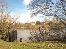
Seattle’s river, the Duwamish, was an impediment rather than a spur to growth because of the wide, shallow tide flats at its mouth and its winding course through the south end of the city. “The way in” to the Puget Sound Lowlands was best traveled by canoe and then shallow draft riverboats. But in the 19-teens, the Port of Seattle dredged and straightened the northern five miles of the meandering river and filled its tide flats to create a navigable waterway and flat industrial land.
The Duwamish River Trail begins at the mouth of the river where bridges connect the Duwamish Peninsula (West Seattle) to the rest of the city. The paved hiking/ biking trail extends more than ten miles to the spot where the Green, White and Black Rivers once joined to form the Duwamish.
The first several miles are lined with industry, but a park at T-107 (a Port of Seattle terminal site) reveals the human-scale history of the river. Across the street is the Duwamish Longhouse and Cultural Center, 4705 West Marginal Way SW. After passing through the community of South Park, the trail crosses the river at North Wind’s Fish Weir, an ancient cultural site. From there the trail follows the natural winding course of the river and ends at Fort Dent Park, 6800 Fort Dent Way. The name comes from a fort and blockhouse, which were never needed, near the site of a Duwamish village. A good place to access the trail is from the Tukwila Community Center at 12424 42nd Ave S. From there you can walk north a mile-and-a-half to the fish weir or south four miles to Fort Dent.
Judy Bentley wrote a book on the historical role of rivers in Vancouver, Everett, Yakima and Spokane, “Walking Washington’s History: Ten Cities.” Her book “Hiking Washington’s History” includes the Duwamish River trail in Seattle and other Washington State locations. For more information, visit www.judybentley.com.
Begin in Vancouver, on the lower Columbia. The American Robert Gray named the river, but it was an English explorer who put Vancouver Point on a map. A British fur-trading company chose this point for its headquarters. When canoe-loads of furs were paddled down the river, more than a thousand people gathered at Fort Vancouver, making it the first real city in the Pacific Northwest in the 1820s. A century and more later, thousands of workers streamed to shipyards in Vancouver during two world wars.
To celebrate its relationship to the river and transform an industrial waterfront into more friendly space, Vancouver has strung together more than five miles of the Columbia River Renaissance Trail. It begins at Waterfront Park, 115 Columbia Way. Sidewalks and paved trails lead through parks, along beaches and past new housing developments on the wide, placid but busy river. Right at the beginning, across Columbia Way on a crosswalk, is a spur trail under the railroad line to the Land Bridge. At significant places along the lower Columbia River, artist Maya Lin has redesigned landmarks at the confluence of Native American, European and American cultures. The land bridge reconnects the river to the fort plain, now the Fort Vancouver National Historic Preserve, worth a day’s rambling on its own.
One mile farther along is a bronze statue of Ilchee, a member of the powerful Chinook tribe who controlled the lower Columbia in the early 1800s. A short distance beyond is Wendy Rose, a stainless-steel welder sporting a jaunty red bandanna. At three-and-a-half miles is a side-trail to the Kaiser Viewing Tower, overlooking the former shipyards where more than 140 Victory ships were built during World War II, many welded by women. The trail continues another 1.5 miles to Wintler Park.
Tri-Cities
From Vancouver, follow the Columbia River 200 miles upstream as it flows over rapids now buried by dams. Past the Cascade Mountains, the hills above the river are dry and brown. Where the Columbia turns north at the Tri-Cities is where hope ended for a waterway across the continent.
But two other rivers, the Snake and the Yakima, flow into the Columbia here from the east and the west. Native Americans lived and fished at the confluence for more than 11,000 years. Tribes gathered in great numbers when the salmon swam up the Columbia. Lewis and Clark and their Corps of Discovery canoed down the Snake and arrived at the Columbia on October 16, 1805, knowing they had found the last leg of their journey across the continent. The Indians invited the Corps to join them in a smoke and an exchange of food and gifts.
Three cities developed on the banks of the three rivers. Pasco and Kennewick grew along railroad routes and from farming irrigated by the Columbia Irrigation Canal. Richland was a sleepy ranching and farming town, the commercial center of rich land watered by the rivers. Then the federal government chose Hanford as a site to produce plutonium during World War II. Transformed almost overnight, Richland became a nuclear city.
The Sacagawea Heritage Trail, named after the one woman in the Corps of Discovery, connects the three cities with a 23- mile paved loop. The trail follows both sides of the Columbia from its confluence with the Snake on the south to its confluence with the Yakima on the north end. You may walk or bike the trail in segments, one city at a time. Sacajawea State Park, on the Pasco side at the confluence of the Snake and the Columbia, is a good starting point on the southern end of the trail. The Hanford Reach Interpretive Center is a good access spot on the Kennewick/Richland side at 1943 Columbia Park Trail.
Other trails and spurs intersect and extend the trail, including the Richland Riverfront Trail, which focuses on nuclear history. It may be picked up at Howard Amon Park, 500 Amon Park Drive.
Yakima
The Yakima River flows into the Columbia after a long journey from the Cascade Mountains through the Yakima Valley. The federal Reclamation Act of 1902 authorized thousands of miles of irrigation canals, turning the valley into the “fruit bowl of the nation.”
The city of Yakima, at the confluence of the Yakima and Naches rivers, is the fruit bowl’s market hub. From Fruit Row on the railroad lines downtown, fruit and vegetables were stored, dried, canned or packed, and shipped to the nation and the world.
The Yakima Greenway parallels the two rivers for more than twenty miles with ten access points. The trailhead on the west end is at Myron Lake. The Century Landing is on the south end.
Midway through the trail is the Naches River railroad bridge. Hobos gathered beneath it in the days when it was possible to hop a passing freight train to the next job. Twelve-year-old William O. Douglas, the Supreme Court justice-to-be, camped and talked with the hobos when he headed out of Yakima on his periodic rambles into the mountains.
Rotary Lake, near the junction of rivers, is the former millpond for the Cascade Lumber Company. A thousand logs from upriver logging would float down the Yakima River and arrive each day during the spring log drives. Since the mill closed in 2006, private efforts have reclaimed the riverfront for walking, biking and fishing.
Wenatchee
On his ambitious exploration of the length of the Columbia River for the Northwest Fur Company, David Thompson canoed past the mouth of the Wenatchee River on July 7, 1811. Eighty years later a city grew where the two rivers converge.
Wenatchee had both water transportation and a railway line, the Great Northern, going through town, but the river was hard to navigate. Thompson had to portage his canoes around rapids. The land on narrow benches above the river was dry with poor soil. Not until large-scale irrigation diverted water from the Wenatchee River starting in 1904 did the land produce fruit and launch Wenatchee as the self-proclaimed Apple Capital of the World.
Rufus Woods moved to town a year later and started a newspaper. Woods was a relentless promoter of dams on the Columbia. As Franklin Delano Roosevelt made campaign promises in 1932, he included building the Grand Coulee Dam but it took all the political and publicity power Woods and others could muster to counter arguments they were “coulee communists” for advocating publicly-owned power. The Grand Coulee opened some 99 miles upstream in 1942, in time to power aluminum production for WWII. The Rock Island and Rocky Reach dams turned the mid- Columbia into a powerhouse.
The Apple Capital Loop borders the now placid river. The multi-use trail stretches five miles on the west and another five miles on the east. On the east side, there is access and parking at the 19th Street trailhead. On the west side, access the loop at Confluence Park, Walla Walla Point Park and the Riverfront Park. The loop crosses the river on the north end over the Odabashian Bridge and on a footbridge on the southern end. Best walking parts are between the parks on the west side or along the less urban east side.
Spokane
North of Wenatchee, the Columbia curves east again through the Grand Coulee Dam, pooling in Lake Roosevelt. The Spokane River flows in from the east, a 111-mile journey from Lake Coeur d’Alene, Idaho. Historically the river was a salmon river, but a city grew on its banks because of the power that could be harnessed by three falls that run through the heart of Spokane. Mills ground grain into flour and shipped it as far away as London, England. In 1910, the Washington Water Power Company built a substation on the river, generating electric power for the next 120 years, longer than any other hydroelectric site operating in Washington.
Spokane abused the river in its midst until the city undertook a world’s fair, Expo 74, with an environmental theme. Riverfront Park in the heart of downtown would be the centerpiece. Power grabs were reduced to increase the river’s flow; railroad tracks were pried from its islands and water pollution was abated.
The Centennial Trail runs through the park, part of a 36-mile trail along the river from Spokane House, an 1800s fur trading post, to Horse Slaughter Camp, site of a military conflict near the Idaho border. Access the trail in Spokane at Riverfront Park and walk or bike to your heart’s content in either direction.
Leaving the Columbia River and the east side of the state, head west to Puget Sound where multiple rivers flow down from the Cascade Mountains.
Everett
Begin in Vancouver, on the lower Columbia. The American Robert Gray named the river, but it was an English explorer who put Vancouver Point on a map. A British fur-trading company chose this point for its headquarters. When canoe-loads of furs were paddled down the river, more than a thousand people gathered at Fort Vancouver, making it the first real city in the Pacific Northwest in the 1820s. A century and more later, thousands of workers streamed to shipyards in Vancouver during two world wars.
To celebrate its relationship to the river and transform an industrial waterfront into more friendly space, Vancouver has strung together more than five miles of the Columbia River Renaissance Trail. It begins at Waterfront Park, 115 Columbia Way. Sidewalks and paved trails lead through parks, along beaches and past new housing developments on the wide, placid but busy river. Right at the beginning, across Columbia Way on a crosswalk, is a spur trail under the railroad line to the Land Bridge. At significant places along the lower Columbia River, artist Maya Lin has redesigned landmarks at the confluence of Native American, European and American cultures. The land bridge reconnects the river to the fort plain, now the Fort Vancouver National Historic Preserve, worth a day’s rambling on its own.
One mile farther along is a bronze statue of Ilchee, a member of the powerful Chinook tribe who controlled the lower Columbia in the early 1800s. A short distance beyond is Wendy Rose, a stainless-steel welder sporting a jaunty red bandanna. At three-and-a-half miles is a side-trail to the Kaiser Viewing Tower, overlooking the former shipyards where more than 140 Victory ships were built during World War II, many welded by women. The trail continues another 1.5 miles to Wintler Park.
Tri-Cities
From Vancouver, follow the Columbia River 200 miles upstream as it flows over rapids now buried by dams. Past the Cascade Mountains, the hills above the river are dry and brown. Where the Columbia turns north at the Tri-Cities is where hope ended for a waterway across the continent.
But two other rivers, the Snake and the Yakima, flow into the Columbia here from the east and the west. Native Americans lived and fished at the confluence for more than 11,000 years. Tribes gathered in great numbers when the salmon swam up the Columbia. Lewis and Clark and their Corps of Discovery canoed down the Snake and arrived at the Columbia on October 16, 1805, knowing they had found the last leg of their journey across the continent. The Indians invited the Corps to join them in a smoke and an exchange of food and gifts.
Three cities developed on the banks of the three rivers. Pasco and Kennewick grew along railroad routes and from farming irrigated by the Columbia Irrigation Canal. Richland was a sleepy ranching and farming town, the commercial center of rich land watered by the rivers. Then the federal government chose Hanford as a site to produce plutonium during World War II. Transformed almost overnight, Richland became a nuclear city.
The Sacagawea Heritage Trail, named after the one woman in the Corps of Discovery, connects the three cities with a 23- mile paved loop. The trail follows both sides of the Columbia from its confluence with the Snake on the south to its confluence with the Yakima on the north end. You may walk or bike the trail in segments, one city at a time. Sacajawea State Park, on the Pasco side at the confluence of the Snake and the Columbia, is a good starting point on the southern end of the trail. The Hanford Reach Interpretive Center is a good access spot on the Kennewick/Richland side at 1943 Columbia Park Trail.
Other trails and spurs intersect and extend the trail, including the Richland Riverfront Trail, which focuses on nuclear history. It may be picked up at Howard Amon Park, 500 Amon Park Drive.
Yakima
The Yakima River flows into the Columbia after a long journey from the Cascade Mountains through the Yakima Valley. The federal Reclamation Act of 1902 authorized thousands of miles of irrigation canals, turning the valley into the “fruit bowl of the nation.”
The city of Yakima, at the confluence of the Yakima and Naches rivers, is the fruit bowl’s market hub. From Fruit Row on the railroad lines downtown, fruit and vegetables were stored, dried, canned or packed, and shipped to the nation and the world.
The Yakima Greenway parallels the two rivers for more than twenty miles with ten access points. The trailhead on the west end is at Myron Lake. The Century Landing is on the south end.
Midway through the trail is the Naches River railroad bridge. Hobos gathered beneath it in the days when it was possible to hop a passing freight train to the next job. Twelve-year-old William O. Douglas, the Supreme Court justice-to-be, camped and talked with the hobos when he headed out of Yakima on his periodic rambles into the mountains.
Rotary Lake, near the junction of rivers, is the former millpond for the Cascade Lumber Company. A thousand logs from upriver logging would float down the Yakima River and arrive each day during the spring log drives. Since the mill closed in 2006, private efforts have reclaimed the riverfront for walking, biking and fishing.
Wenatchee
On his ambitious exploration of the length of the Columbia River for the Northwest Fur Company, David Thompson canoed past the mouth of the Wenatchee River on July 7, 1811. Eighty years later a city grew where the two rivers converge.
Wenatchee had both water transportation and a railway line, the Great Northern, going through town, but the river was hard to navigate. Thompson had to portage his canoes around rapids. The land on narrow benches above the river was dry with poor soil. Not until large-scale irrigation diverted water from the Wenatchee River starting in 1904 did the land produce fruit and launch Wenatchee as the self-proclaimed Apple Capital of the World.
Rufus Woods moved to town a year later and started a newspaper. Woods was a relentless promoter of dams on the Columbia. As Franklin Delano Roosevelt made campaign promises in 1932, he included building the Grand Coulee Dam but it took all the political and publicity power Woods and others could muster to counter arguments they were “coulee communists” for advocating publicly-owned power. The Grand Coulee opened some 99 miles upstream in 1942, in time to power aluminum production for WWII. The Rock Island and Rocky Reach dams turned the mid- Columbia into a powerhouse.
The Apple Capital Loop borders the now placid river. The multi-use trail stretches five miles on the west and another five miles on the east. On the east side, there is access and parking at the 19th Street trailhead. On the west side, access the loop at Confluence Park, Walla Walla Point Park and the Riverfront Park. The loop crosses the river on the north end over the Odabashian Bridge and on a footbridge on the southern end. Best walking parts are between the parks on the west side or along the less urban east side.
Spokane
Begin in Vancouver, on the lower Columbia. The American Robert Gray named the river, but it was an English explorer who put Vancouver Point on a map. A British fur-trading company chose this point for its headquarters. When canoe-loads of furs were paddled down the river, more than a thousand people gathered at Fort Vancouver, making it the first real city in the Pacific Northwest in the 1820s. A century and more later, thousands of workers streamed to shipyards in Vancouver during two world wars.
To celebrate its relationship to the river and transform an industrial waterfront into more friendly space, Vancouver has strung together more than five miles of the Columbia River Renaissance Trail. It begins at Waterfront Park, 115 Columbia Way. Sidewalks and paved trails lead through parks, along beaches and past new housing developments on the wide, placid but busy river. Right at the beginning, across Columbia Way on a crosswalk, is a spur trail under the railroad line to the Land Bridge. At significant places along the lower Columbia River, artist Maya Lin has redesigned landmarks at the confluence of Native American, European and American cultures. The land bridge reconnects the river to the fort plain, now the Fort Vancouver National Historic Preserve, worth a day’s rambling on its own.
One mile farther along is a bronze statue of Ilchee, a member of the powerful Chinook tribe who controlled the lower Columbia in the early 1800s. A short distance beyond is Wendy Rose, a stainless-steel welder sporting a jaunty red bandanna. At three-and-a-half miles is a side-trail to the Kaiser Viewing Tower, overlooking the former shipyards where more than 140 Victory ships were built during World War II, many welded by women. The trail continues another 1.5 miles to Wintler Park.
Tri-Cities
From Vancouver, follow the Columbia River 200 miles upstream as it flows over rapids now buried by dams. Past the Cascade Mountains, the hills above the river are dry and brown. Where the Columbia turns north at the Tri-Cities is where hope ended for a waterway across the continent.
But two other rivers, the Snake and the Yakima, flow into the Columbia here from the east and the west. Native Americans lived and fished at the confluence for more than 11,000 years. Tribes gathered in great numbers when the salmon swam up the Columbia. Lewis and Clark and their Corps of Discovery canoed down the Snake and arrived at the Columbia on October 16, 1805, knowing they had found the last leg of their journey across the continent. The Indians invited the Corps to join them in a smoke and an exchange of food and gifts.
Three cities developed on the banks of the three rivers. Pasco and Kennewick grew along railroad routes and from farming irrigated by the Columbia Irrigation Canal. Richland was a sleepy ranching and farming town, the commercial center of rich land watered by the rivers. Then the federal government chose Hanford as a site to produce plutonium during World War II. Transformed almost overnight, Richland became a nuclear city.
The Sacagawea Heritage Trail, named after the one woman in the Corps of Discovery, connects the three cities with a 23- mile paved loop. The trail follows both sides of the Columbia from its confluence with the Snake on the south to its confluence with the Yakima on the north end. You may walk or bike the trail in segments, one city at a time. Sacajawea State Park, on the Pasco side at the confluence of the Snake and the Columbia, is a good starting point on the southern end of the trail. The Hanford Reach Interpretive Center is a good access spot on the Kennewick/Richland side at 1943 Columbia Park Trail.
Other trails and spurs intersect and extend the trail, including the Richland Riverfront Trail, which focuses on nuclear history. It may be picked up at Howard Amon Park, 500 Amon Park Drive.
Yakima
The Yakima River flows into the Columbia after a long journey from the Cascade Mountains through the Yakima Valley. The federal Reclamation Act of 1902 authorized thousands of miles of irrigation canals, turning the valley into the “fruit bowl of the nation.”
The city of Yakima, at the confluence of the Yakima and Naches rivers, is the fruit bowl’s market hub. From Fruit Row on the railroad lines downtown, fruit and vegetables were stored, dried, canned or packed, and shipped to the nation and the world.
The Yakima Greenway parallels the two rivers for more than twenty miles with ten access points. The trailhead on the west end is at Myron Lake. The Century Landing is on the south end.
Midway through the trail is the Naches River railroad bridge. Hobos gathered beneath it in the days when it was possible to hop a passing freight train to the next job. Twelve-year-old William O. Douglas, the Supreme Court justice-to-be, camped and talked with the hobos when he headed out of Yakima on his periodic rambles into the mountains.
Rotary Lake, near the junction of rivers, is the former millpond for the Cascade Lumber Company. A thousand logs from upriver logging would float down the Yakima River and arrive each day during the spring log drives. Since the mill closed in 2006, private efforts have reclaimed the riverfront for walking, biking and fishing.
Wenatchee
Begin in Vancouver, on the lower Columbia. The American Robert Gray named the river, but it was an English explorer who put Vancouver Point on a map. A British fur-trading company chose this point for its headquarters. When canoe-loads of furs were paddled down the river, more than a thousand people gathered at Fort Vancouver, making it the first real city in the Pacific Northwest in the 1820s. A century and more later, thousands of workers streamed to shipyards in Vancouver during two world wars.
To celebrate its relationship to the river and transform an industrial waterfront into more friendly space, Vancouver has strung together more than five miles of the Columbia River Renaissance Trail. It begins at Waterfront Park, 115 Columbia Way. Sidewalks and paved trails lead through parks, along beaches and past new housing developments on the wide, placid but busy river. Right at the beginning, across Columbia Way on a crosswalk, is a spur trail under the railroad line to the Land Bridge. At significant places along the lower Columbia River, artist Maya Lin has redesigned landmarks at the confluence of Native American, European and American cultures. The land bridge reconnects the river to the fort plain, now the Fort Vancouver National Historic Preserve, worth a day’s rambling on its own.
One mile farther along is a bronze statue of Ilchee, a member of the powerful Chinook tribe who controlled the lower Columbia in the early 1800s. A short distance beyond is Wendy Rose, a stainless-steel welder sporting a jaunty red bandanna. At three-and-a-half miles is a side-trail to the Kaiser Viewing Tower, overlooking the former shipyards where more than 140 Victory ships were built during World War II, many welded by women. The trail continues another 1.5 miles to Wintler Park.
Tri-Cities
From Vancouver, follow the Columbia River 200 miles upstream as it flows over rapids now buried by dams. Past the Cascade Mountains, the hills above the river are dry and brown. Where the Columbia turns north at the Tri-Cities is where hope ended for a waterway across the continent.
But two other rivers, the Snake and the Yakima, flow into the Columbia here from the east and the west. Native Americans lived and fished at the confluence for more than 11,000 years. Tribes gathered in great numbers when the salmon swam up the Columbia. Lewis and Clark and their Corps of Discovery canoed down the Snake and arrived at the Columbia on October 16, 1805, knowing they had found the last leg of their journey across the continent. The Indians invited the Corps to join them in a smoke and an exchange of food and gifts.
Three cities developed on the banks of the three rivers. Pasco and Kennewick grew along railroad routes and from farming irrigated by the Columbia Irrigation Canal. Richland was a sleepy ranching and farming town, the commercial center of rich land watered by the rivers. Then the federal government chose Hanford as a site to produce plutonium during World War II. Transformed almost overnight, Richland became a nuclear city.
The Sacagawea Heritage Trail, named after the one woman in the Corps of Discovery, connects the three cities with a 23- mile paved loop. The trail follows both sides of the Columbia from its confluence with the Snake on the south to its confluence with the Yakima on the north end. You may walk or bike the trail in segments, one city at a time. Sacajawea State Park, on the Pasco side at the confluence of the Snake and the Columbia, is a good starting point on the southern end of the trail. The Hanford Reach Interpretive Center is a good access spot on the Kennewick/Richland side at 1943 Columbia Park Trail.
Other trails and spurs intersect and extend the trail, including the Richland Riverfront Trail, which focuses on nuclear history. It may be picked up at Howard Amon Park, 500 Amon Park Drive.
Yakima
Begin in Vancouver, on the lower Columbia. The American Robert Gray named the river, but it was an English explorer who put Vancouver Point on a map. A British fur-trading company chose this point for its headquarters. When canoe-loads of furs were paddled down the river, more than a thousand people gathered at Fort Vancouver, making it the first real city in the Pacific Northwest in the 1820s. A century and more later, thousands of workers streamed to shipyards in Vancouver during two world wars.
To celebrate its relationship to the river and transform an industrial waterfront into more friendly space, Vancouver has strung together more than five miles of the Columbia River Renaissance Trail. It begins at Waterfront Park, 115 Columbia Way. Sidewalks and paved trails lead through parks, along beaches and past new housing developments on the wide, placid but busy river. Right at the beginning, across Columbia Way on a crosswalk, is a spur trail under the railroad line to the Land Bridge. At significant places along the lower Columbia River, artist Maya Lin has redesigned landmarks at the confluence of Native American, European and American cultures. The land bridge reconnects the river to the fort plain, now the Fort Vancouver National Historic Preserve, worth a day’s rambling on its own.
One mile farther along is a bronze statue of Ilchee, a member of the powerful Chinook tribe who controlled the lower Columbia in the early 1800s. A short distance beyond is Wendy Rose, a stainless-steel welder sporting a jaunty red bandanna. At three-and-a-half miles is a side-trail to the Kaiser Viewing Tower, overlooking the former shipyards where more than 140 Victory ships were built during World War II, many welded by women. The trail continues another 1.5 miles to Wintler Park.
Tri-Cities
Latest Stories

April is National Volunteer Month
Volunteer ideas for you to consider during National Volunteer Month in April and year-round
READ MORE...
Death Doula with Northwest Center for Creative Aging
Northwest Center for Creative Aging will present a program about navigating the end-of-life with a service called "Death Doula"
READ MORE...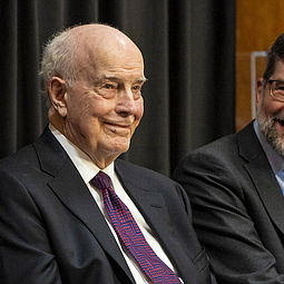
Former WA Gov. Dan Evans Feted for Energy & Conservation Work
Former Washington Gov. Daniel J. Evans, 98, was called on to impart some words of wisdom
READ MORE...